Sunday, April 17, 2011

Okifenokee

Once again we were off for a road trip of sorts.Fargo Georgia to the Okefinokee Swamp and then on to Cumberland Island. This is my fourth trip to the swamp and I just have to say I am in love. One day maybe I will move as close to it as I can.


First Day we set up camp the weather is perfect and we go for a walk on one of the trails. Unfortunately the sill area is closed for a boat ramp construction project. The sill area is beautiful because it is an area where a lot of the water fowl roost and the wildlife come out to feed in the evening. But on our walk just past the welcome center in the water is a small baby alligator amongst the lily pads. Also a small frog is on the edge of the water no bigger than a nickel. A child's smile spreads across my face and I feel as if I am the luckiest girl on earth.


The next day we wake up early....coffee in hand, camera bags and snacks to hit the water by 730 am. At the welcome center we rent the small motor boat for a small fee and load are little gear. Tom navigates us through the small canal like entrance into the bigger water. We can see a mist ahead on the water and when we hit the big water to the left a mist rises from the swamp. The alligators are out in abundance we can see them swimming in the mist looking for the morning meal. Occasionally they will bellow out which sounds sometimes like a large bull frog and sometimes like a lion in the woods. Cypress trees, tall pines and a variety of other trees covered with Spanish moss loom on either side of the water, thousands of lily pads with blooms just about to open lay beneath them.
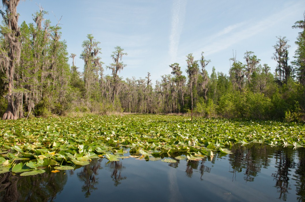
As the sun begins to burn off the mist up ahead in a couple of tall trees the buzzards are roosting. Waking up from their sleep they are sunning themselves. Around twenty-five birds are in the trees some with wings spread catching the morning sun. As we navigate through the waters of the Okefenokee many other water trails exist but clogged with lily pads and cypress trees motor boats are not allowed. I looked longingly wanting to explore these places that seem untouched by man. Water fowl swoop from the trees ahead of us, herons, ducks, egrets and the always present alligator close at hand.


The first time I saw the swamp I was in awe of it's beauty and wildness. On this trip the beauty brought tears to my eyes. The history of the swamp and it's people is an interesting one. For anyone interested I would recommend, "Okefinokee Album" by Delma Presley and Frances Harper.


Photographs can't show the beauty of the swamp nor the way it makes me feel. I have posted a few of my favorites from the hundreds I have taken to try to keep with me the feeling of the swamp.

Friday, February 5, 2010

Okefinokee

The Okefinokee Swamp

Just a few immediate thoughts of a beautiful place.
Into the land of the gators, reflections of life in the past, a look into another world of fairy flies & mirror images where one's imagination can easily deceive. I looked into the reflections and in them saw a world like no other but how can that be? The reflections were of this world, but I could not look at this one while navigating the winding water ways I was drawn only to the reflections. I pondered on what lie beneath the surface of all that beauty. I know there is a dark place under there where alligators lurk waiting for the likes of me to become lost in the magic of the swamp. But somehow I felt within the depths of the water there lay a world of fairy lights and fairy flies that danced in the evening sun. There is a beauty within the swamp the reflections make it seem as if there is no where else to go as if the trail has ended. Then and only then do the eyes look up into this world to find the path which one must take to take the next step of the journey.

Thursday, December 31, 2009

Abrams Falls

Abrams Falls

Went to visit my sister in Rockford Tn. a couple of weeks back. Just 30 short minutes to Great Smoky Mountains National Park. So I could not resist going for a hike. Cades Cove is a lovely area with a one way loop road with great views of the mountains, open fields and wildlife.


Abrams falls was a 2.5 mile hike over two ridges before descending to the falls. When you reach the bottom you are well rewarded with the view of the falls. Not many people on the trail this time of year but I can imagine what it is like in the spring and summer. After the hike I continued on the loop road which is approximately 13 miles around. This is a beautiful place and can't wait to go back to explore more trails and waterfalls. Above are a few pics from my adventure.

Monday, October 12, 2009

Me and my shadow unaccompanied

I find myself doing more alone than with others. There is solace in the solitude of nature for me. The dialogue with oneself is uncensored. No mimicry or masks invade the conversation with oneself. Only the truth can be found within this conversation. Where the duality of ones opinion of self and feelings converge with veracity.

Just a few photos from m
y wanderings in nature while wandering through the paths in my mind.


Friday, July 31, 2009

Doughton Park Trails


(on a hill early am above picnic area Doughton Park)

Doughton Park has some wonderful trails for all types of hikers. Short ones with great views to Fodder's Stack and Wild Cat Rock Overlook. For a great wildflower hike Bluff Mountain Trail from the picnic area is very nice. Park up at the turn around area, cut up the hill through the fence and keep right. If you go left that takes you to the Bluff Ridge Primitive Trail past the shelter. Going right you will come to a rocky area and the trail winds down through the woods and along the edge of the BRP. On previous posts I talked about Caudle Cabin and the Basin Creek Trail. This is my favorite by far. Looking forward to trying the Bluff Ridge Primitive and Cedar Ridge Trail. Here are a few photos from the area.


(Tom on same hill as the sun is rising)


(Tom jumping the fence at Picnic parking area)

(Caleb Jumping same fence)

Tom & Caleb are the best hiking partners, you never know what they will be up to!
My upcoming blog will be on what I call...... In Search of............ a Tom Wise adventure for sure.


I love this hike because you never know what you will see.


(Wildflowers along Bluff Ridge Trail)


(Turk's Cap Lily, Bluff Ridge Trail)


(Leather Flowers Below)


(Tom on top of Fodder's Stack)

Wednesday, July 22, 2009

Short on time

Have been behind on posting on my recent hikes. Hope to do so soon. Meanwhile my friend Tom has been posting so take a look. He is offering photography classes at the Yadkinville Arts Council in NC. Just click on title of post and it will link you to the site with info. Sidemeat

Friday, May 22, 2009

Basin Creek Trail /Caudill Cabin

Found a great four star hike the other day called Basin Creek Trail. It is part of Daughton Park on the BRP. Basin Creek Trail is at the bottom entrance to Daughton Park( which is not) on the BRP. Instead if one comes North or South I -77 you will want to get on 21 bypass towards Sparta. Stay on 21 until you see a sign for Stone Mt. State Park, right past the sign you will make a left onto Traphill Road. Go about 2.2 miles you will go over a bridge, immediately after the bridge turn left into a parking area. Across the road is the Daughton Park lower entrance. This is the Grassy Gap Fire Road.

You will have a nice wide trail that follows Basin Creek.Very shortly after being on Grassy Gap Fire Road you will pass an old dam. As you walk further on amongst the old pines, ( I mean old these trees are for me the largest pines I have seen in this area of NC.) eventually you will pass the backwoods camping area on your left this is about 1.5 miles in on the fire road. Then you will come upon a fork where the road splits go right (follow the signs here) to Basin Creek Trail. The next 3.3 miles of your day will be spectacular!


The trail winds up and down (mostly up) along the wide creek with huge stones & trees in the middle of it. A little over 2 miles and you will come to a large waterfall. There are smaller falls along the way. The moss and flora are beautiful.

As you wander your way toward your destination which is Caudill Cabin (around 100 yrs old) think about the fact that a family lived and prospered here. It was amazing to me to think that 100 years ago in this remote place families were living and surviving in small one or two room cabins with (as my friend says) 10 to over 20 " head of youngin'." Can you imagine living in this remote place now with just two of them?


On the trail there are many stream crossings most your get your ankles wet if you are not an agile jumper (I'm not). There are various chimneys left from past cabins long since gone. The final ascent is a little steep as you break into a clearing and there sits Caudill Cabin. The panorama is amazing with views of Wild Cat Rocks & Fodder Stacks above. Inside the cabin is a guest book if you wish to sign. It also has information on the Caudill's family tree. When you step into the cabin think that I believe the book said 10 of 14 children were delivered in this cabin. That means 16 people lived in this cabin. Whew! The book also speaks to the fact that the cabin was restored in 2001 (they did an excellent job) and that in 1916 there was a great flood that wiped out the Basin Creek community and that this cabin is as far as they know the only structure that survived the flood.

As I said this is an excellent moderate hike for hikers who don't mind some uphill. For those who like the flat land it might be considered strenuous. There are several other trails from this entrance and one right down the road. I can't wait to explore these I think there are a total of five,( Basin Creek, Bluff Ridge, Grassy Gap, Cedar Ridge and Flat Rock Ridge.) I have been going to Stone Mt. for a couple of years now and never knew this trail was 10-15 minute drive past it.Take a look at my Tom's blog, http://tomwise1.wordpress.com/ for delicious photos of this hike & the MST Trail. His website www.tomwisephotos.com has amazing photography of many of our hikes.

Thanks for looking in on me if you have any questions just leave me a comment & I'll get back to you. ~ All who wander are not lost........But those of us who are have more fun!


Sunday, May 17, 2009

Bethabra Village


Bethabra Village in Winston Salem NC is a nice walk if you can't get out of the city for a hike. Founded in 1753 there are several buildings and foundations. I enjoy the few little trails they have depending on the time of year there is some great fauna to be seen.


The gardens are kept by volunteers who are often there to share their knowledge with you about the plants. The medical gardens are one of the first documented in the United States. Very beautiful in the spring with many different flowers blooming interspersed between the vegetables and along the fences.


The boardwalk area that takes you out to the bogs unfortunately has fell into disrepair making it difficult to access after a rain. One can find interesting plants such as these mushrooms which a friend informed
me were called elf ears.


For those who are history buffs there are foundations, old fort posts, and several restored buildings. Tours are available also if this is something you like.


All in all a nice walk.

Thursday, January 1, 2009

Stone Mountain, NC


(photo above: view of Stone Mt. from homestead)

Stone Mountain
Roaring Gap, NC

Stone Mountain is a great day hike for those in the Winston Salem area.
Approximately a 45 minute drive to great hiking. If you like waterfalls this is a wonderful place to visit. I have traversed this park many times in the past two years and always find it beautiful anytime of the year. In the spring the colors are amazing and little alcoves by the stream side come alive with vivid greens of the flora. In the summer there many points to stop and enjoy the water, be it in a pool at the base of a waterfall or the streambed itself. Of course in the fall it is ablaze with the leaves changing.
(photo left stairs going up trail from lower parking lot)
I personally like the Stone Mt. Loop trail, starting at the lower parking lot makes a more strenuous hike. The views at the top are amazing and well worth the climb. The park has recently added wooden stairs to a large part of the trail going up from the lower parking lot. This makes the trail a lot easier to follow to the top. Once you reach the summit itself you have views of the homestead below and the surrounding mountains. Pack some snacks and sit down and enjoy the breeze, or lay down on the rock for some wonderful Vitamin D. Following the trail you can reach the Stone Mt. Falls a 200 ft. cascading waterfall with a pool at the bottom to play in.

Middle and lower falls trails can be picked up off of the Stone Mt. loop trail and is usually a nice quiet hike along the stream with beautiful fauna.The middle and lower falls are not that big but as I said if you want a quiet hike with less people this is a good trail.(photo right Stone Mt. falls)

Widows Falls is accessible past the lower parking lot on the right side of the road limited parking is available. It is a short walk to this beautiful waterfall. Usually very busy in the summer with families who
gather to slide down the rocks into a shallow pool.
(photo right Widows Falls)
However if you like a solitary hike, a path leads you to the back country parking area where you can backpack in and spend the night if you choose.It is a great day hike also.This trail is steep at the beginning but once you get to the top and go around the bend following the creek bed the flora is absolutely amazing. I have seen only one or two people on this trail when hiking. Keeping your eyes open to the left of the trail there are remnants of a chimney from a home that once stood there. Widows Creek and MST trails are both accessed this way.(MST is definitely an up hill climb for the more serious hiker. Caution is advised as my friend and I encountered a bear on one of our day hikes up this trail.I think the bear was as afraid as I was.) Picking up the Widows creek trail you come to an open area where there are several camping sites to your left and the path continues on to more camping sites. If you go to your right, just off the trail is a secluded waterfall hidden behind some foliage. Do wade over to the falls for some photo ops and re-energizing. Nothing like a cold waterfall to stimulate and refresh one after a hot summer hike.
Stone Mt. has something for everyone, there is a homestead and from there you have a spectacular view of Stone Mt. summit. Water to play in, picnicking, camping, and wildlife abounds. You can hear the birds chirping and deer are plentiful and friendly. They are frequently found by the road side so it is important to drive slow through the park to protect them. Many times people are stopped in the road to feed them apples and such. I think this is a great park with some excellent hiking and fauna.

Please visit my friend Tom Wise's website for more photos of Stone Mountain
http://www.tomwisephotos.com/gallery/5618324_D8fUv#206564896_bf8zT

Friday, November 14, 2008

Tallulah Gorge


Tallulah Gorge
Highway 441

Tallulah Falls, Ga.

(left)Hurricane Fall 2.5 miles round trip
Strenuous

This is a great hike for those who like climbing over boulders and logs . Some of the rock surfaces are very steep and slippery so caution is needed. Access to the trail is behind the Interpretive Center, where permits to access the canyon floor can be obtained. We started with a easy stair case down, which at one point crosses a suspension bridge 80 feet over the gorge floor. A little scary for me as I am not big on suspension bridges or heights. I recommend going with someone you trust and won’t let you back out! Finish the stairs (all 1,099 of them) and then you cross to the other side of the gorge by boulder hopping. Spectacular views from the suspension bridge and from the bottom of the falls. The trail continues once you cross to the other side. Some of the surfaces are steep and slippery so caution is advised. At the end of the trail is a reward for those young at heart. Sliding Rock pool!


Very nice in the summer. I would recommend a change of clothes or time to dry off before the climb back up the gorge. There are several other trails one is off the staircase and it is called the North Rim Trail. It’s about ¾ of a mile and leads back to the Interpretive Center. There are some very nice views and overlooks on this trail also. There is a view of the Tallulah Falls Dam. The link below has all the information you will need, directions etc. One last note if you decide to take the trip it is well worth it to find a little country store called Goats on the Roof. A wonderfully amusing site to finish the day.


gastateparks.org/info/tallulah/